25 Jun, 2014
Photogrammetry is an important technique to capture the metric data of an object (shape and position) through the acquisition and analysis of pairs of frames.
Through the photogrammetry you can identify the spatial position of all the points of interest of the object considered. Today aerial photography is most used: its application in surveying the territory is constantly spreading. Although born in parallel to photography, to the relief of the architecture has become one of the most reliable tools and immediate acquisition of metric and thematic data from the territory.
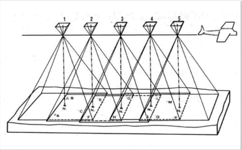
Through aerial photography, the ground is immortalized with streaks of frames at regular intervals (for it is maintained uniform air velocity along straight trajectories and at a constant height). After making the flights and their photographs will proceed to the mountains to get the GPS ground control points. After acquiring all the data, you get to image. In a first phase of the frame orientation will follow the return, which consists of the final product: the 3D drawing object.
Below, a drawing showing how the camera takes images for photogrammetric technique:
The work is now done entirely by special photogrammetric software for computers. With the development of remote controlled aircraft and the lowering of costs of the necessary photographic equipment, has developed a simpler and more rapid use of this technique; the so-called photogrammetry proximity.
Photogrammetry Proximity is mainly used to not particularly large areas and allows diacquisire data in application scenarios such as agriculture, monitoring of industrial systems, remote sensing and others. The spatial resolution is greater than the images provided from regular airplanes and costs are reduced infinitely.
Kim has carried out research and practical tests on photogrammetry proximity applications. They were used in both acquisition sensors mounted on the aircraft remotely piloted both terrestrial instrumentation.
Of fundamental importance, in addition to the drone, it is the GPS positioning sensor that ensures the accuracy of the readings made. They were then installed a camera, a light multi-spectral sensor designed especially for April and two digital cameras, a compact and semi-professional SLR camera with single focal length lens.